We have used the Autopano software to stitch together very large panoramas made up of most of the usable images taken by GeoCam during the HASP balloon flight. Out of 4 GB of memory, there was a minimum of about 2 GB of data that could be used and stitched nicely. The remaining pool of images has too many clouds to allow for scene recognition. The largest panorama is some type of record being 3.7 GB large. However it is sparse and therefore is much smaller when it comes to actual pixel counts (100s of MB). They should be up soon.
Tuesday, October 17, 2006


Wednesday, October 04, 2006
Comparing Satellite Imagery and GeoCam Data
Here is a comparison of images taken by GeoCam (at 36 km up with a Canon Camera) and those taken by Satellites and featured on Google Maps. This is just before entering Moriarty, NM:
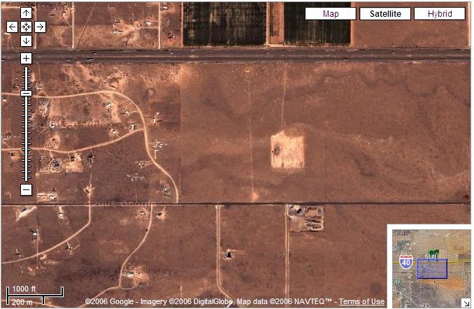
and a frame taken by GeoCam at the same scale

The level of detail afforded by GeoCam is comparable to the next best resolution provided by Google Maps.
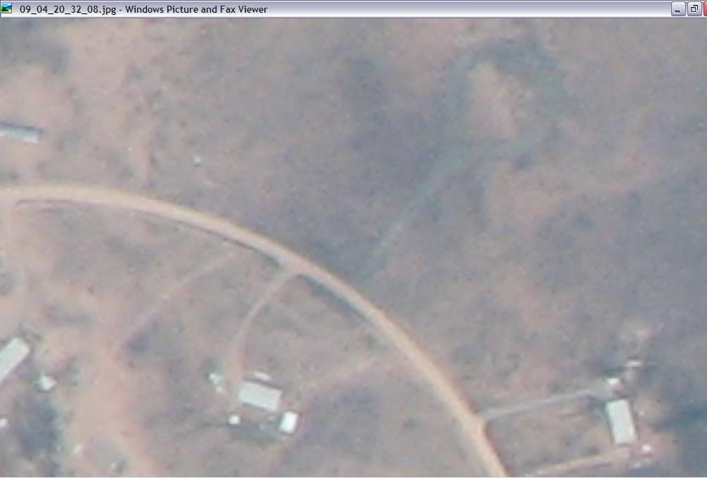
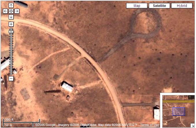
Pedro has estimated that one pixel on GeoCam is about 3.3 feet. Potentially, GeoCam could be provide coverage for a larger swath of land as, in this flight it was tilted at 20 degrees angle from Nadir.

More on that later.
Saturday, September 30, 2006
Being Slashdotted.
Welcome Slashdot. For those of you who are interested in following up on what we are going to do with the data (google maps, Earth, video, high definition desktop background, torrents,...), our RSS feed is at http://hasp-geocam.blogspot.com/atom.xml
We will be responding and expand on the comments of the previous entry on panoramic views in the upcoming days.
Panoramic views
[Slashdot readers]
An interesting use of the data from GeoCam is to see how stitching algorithms are performing with data from our balloon flight. An algorithm developed by Matthew Brown does this automatically through the comparison of SIFT points and a RANSAC algorithm determining good fit. The software is available at the AutoStitch web page.
We first tried stitching five photos together and obtained a reduced file (200 KB as opposed to 5 times 3.2 MB)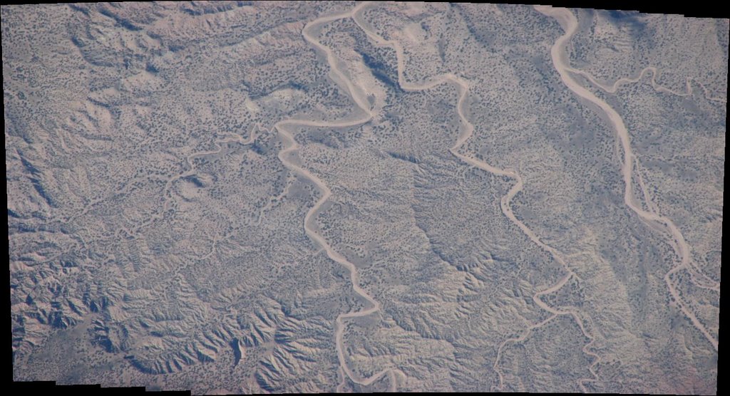
We then went on using about 100-200 frames per panoramas and obtained the following views:
It seems evident that the payload wasn't turning at 1 rpm.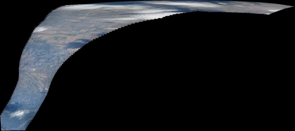

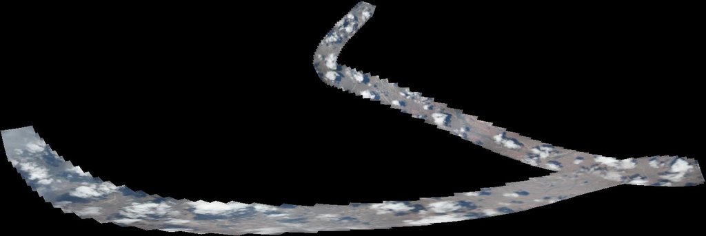

One of the apparent issues seems to be that the comparison for overlap between frames was based on cues from the clouds. Since we took photos at intervals of about 23 seconds, some of these clouds changed location and eventually allowed for some of the panoramas to be unduly stretched.
Thursday, September 28, 2006
Panoramic views - Preliminary results
An interesting use of the data from GeoCam is to see how stitching algorithms are performing with data from our balloon flight. An algorithm developed by Matthew Brown does this automatically through the comparison of SIFT points and a RANSAC algorithm determining good fit. The software is available at the AutoStitch web page.
We first tried stitching five photos together and obtained a reduced file (200 KB as opposed to 5 times 3.2 MB)
We then went on using about 100-200 frames per panoramas and obtained the following views:
It seems evident that the payload wasn't turning at 1 rpm.
One of the apparent issues seems to be that the comparison for overlap between frames was based on cues from the clouds. Since we took photos at intervals of about 23 seconds, some of these clouds changed location and eventually allowed for some of the panoramas to be unduly stretched.
Thursday, September 21, 2006
WOW

Pam and John opened the camera an hour ago and found 1650 images. This is mission success. Each image is about 3.7 MB. We are beginning to work on implementing an interface so that it can be browsable to the rest of the world. The image of this entry is one of these shots taken by GeoCam.
Wednesday, September 20, 2006
NASA Balloon Carries High Altitude Student Platform to the Edge of Space
NASA just came out with a press release on the whole HASP program, take a look at it here.
After reading about this story on Slashdot, I noticed in the comment section that last year, some other team did something similar to our project but it looks like their camera froze on the way up. Our current expectation is that the camera might have gotten very warm once it reached 120,000 feet. We'll see when the payload arrives home. A related effort at NOAA is similarly interesting. We believe that the main difference between all these payloads and ours is our stated goal of making a mapping of these pictures onto real maps (google maps). Our camera was specifically focused to get the most detail out of the landscape whereas most of the helium balloon shots seem to have looked at the wider angle to get shots of "space".
Tuesday, September 12, 2006
Coming home

The crates should have been picked up at Ft. Sumner today and we expect to see them at LSU later this week.
Thursday, September 07, 2006
HASP recovery

The HASP payload, parachute and balloon have been recovered successfully. A brief damage assessment was undertaken and the experiment is going to be packed for shipment back to LSU, and then back to Texas A&M.
We are anxiously waiting for the arrival of GeoCam to evaluate how bad the cloud cover was.
Tuesday, September 05, 2006
Fort Sumner, HASP has landed

According to Greg Guzik:
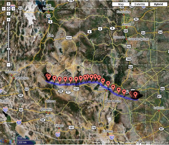
The HASP flight ended at 9:19 UTC today with termination of the balloon. The payload parachuted down, slowing to a speed of about 20 feet / second and impacted at 112 deg 0.45 min W, 35 deg 47.0 min N at 10:02:20 UTC. This location is just a bit south of the Grand Canyon. Needless to say, this was an exciting balloon flight termination. In preparation for termination, the student payloads were turned off at 8:05 UTC. Thus, the HASP flight was 18 hours 12 minutes long and all payloads were at a float altitude of at least 111,800 feet for about 13.5 hours. We are expecting to get HASP back to Ft. Sumner within a couple of days.
Monday, September 04, 2006
Launch and CosmoCam control
HASP was launched at 9:50 am (15:50 UTC) this morning. The payload is now climbing through 7000 meters. Watch CosmoCam for the release of the glider at about 30,000 feet. After that CosmoCam is available for use by anybody.
Sunday, September 03, 2006
It's all your fault, John!

Greg Guzick tells us the following:
The weather just could not give us a break this morning, and a new line of rain storms are developing to the west of us and heading this way. Thus, we have canceled the launch attempt today and will try again tomorrow. In fact, tomorrow’s launch weather should be much, much better. The down side is that Tropical Storm John will be moving up the Baja coast and setting off thunderstorms in the Arizona southwest where HASP is predicted to impact following termination. Thus, with a launch tomorrow we may need to cut down early, resulting in only 10 hours at float.
The new launch target is Monday, September 4 at 7:30 am (13:30 UTC). Pre-launch ops will begin at 3:30 am and pickup will be at 4:00 am.
John is moving off the Baja coast.
Saturday, September 02, 2006
Bad (weather today) is Good (for us tomorrow)

Here are the news from Greg Guzick:
The cold front that has brought some amazingly bad weather to the area today is expected to move further south during the day and evening resulting in improving conditions here. In addition, the high altitude winds continue to slow and current predictions are for about 16 hours at float. Thus, we will be attempting to launch HASP tomorrow morning. Activities will begin here at about 3:30 am Mountain time, targeting a launch time of about 7:30 am Mountain (13:30 UTC). As surface winds are expected to continue to decrease during this time period, launch could be delayed several hours.
CosmoCam will be running during most of the pre-launch period and there may be occasional audio commentary. Live views of the launch area from the tower can be obtained from the CSBF website.
Friday, September 01, 2006
Tic toc tic toc
Here is the latest from Greg Guzick:
The weather brief today is still projecting good weather for Sunday (9/3) morning. In addition, the high altitude winds are starting to come down. Currently we are projecting 15 hours at float. A final decision to go for the Sunday launch will come after tomorrow’s weather brief.
Thursday, August 31, 2006
New Launch Window
Because high altitude winds are still at about 40 knots and low altitude weather is likely to be problematic. The launch window for Sunday, September 3 at 7:30 am mountain time (13:30 UTC) appears to be more favorable.
Wednesday, August 30, 2006
Hanging Tough
 Here is the word from Greg Guzick:
HASP has successfully completed the last hurdles prior to flight; the “hang test” (compatibility test) and the Flight Readiness Review. Thus, at the next opportunity we will launch. As today’s weather briefing an opportunity for launch on Friday 9/1 at 7:30 am local (13:30 UTC) was identified. However, there is a front that may move through the area too quickly bringing high speed low altitude winds. The next, and better looking, opportunity is Sunday 9/3 at 7:30 am local. In either case the high altitude winds are clocking along at 30 to 40 knots. This would bring us to the end of our 550 mile range in about 12 to 14 hours. We will probably be able to make a decision about whether to try for the Friday launch after the Thursday weather briefing at 2:00 pm local (20:00 UTC).
The Google map tracking will also provide you with an idea of where the payload is currently located. Finally, we are expecting to bring the CosmoCam video online within the next day.
For the next several day events may progress rapidly. There we have added a “HASP Status” box on the HASP main page. I will be using this “status box” to distribute the latest news as we get closer to launch. Stay tuned.
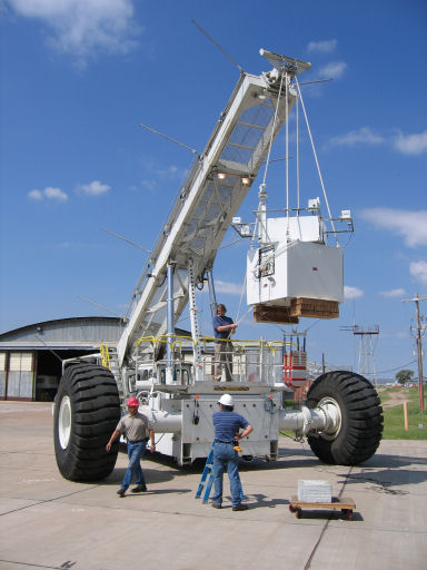
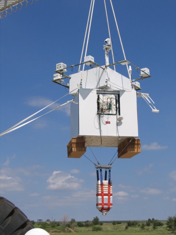
GeoCam is located on the left on this image taken during the Hang test.
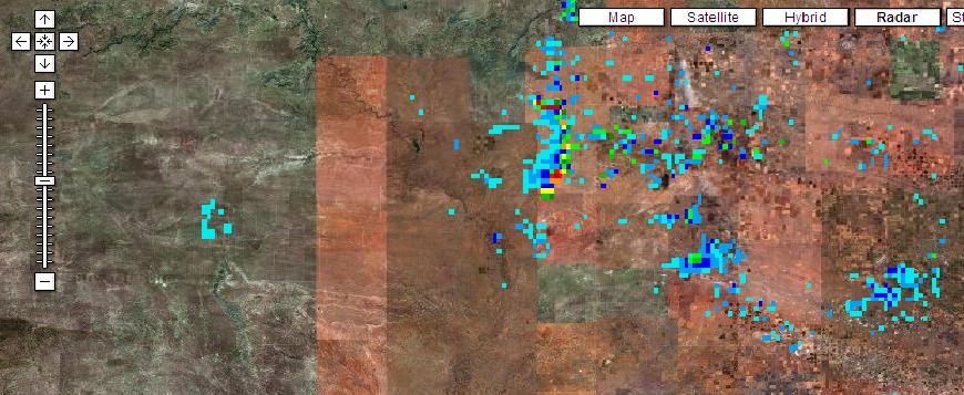
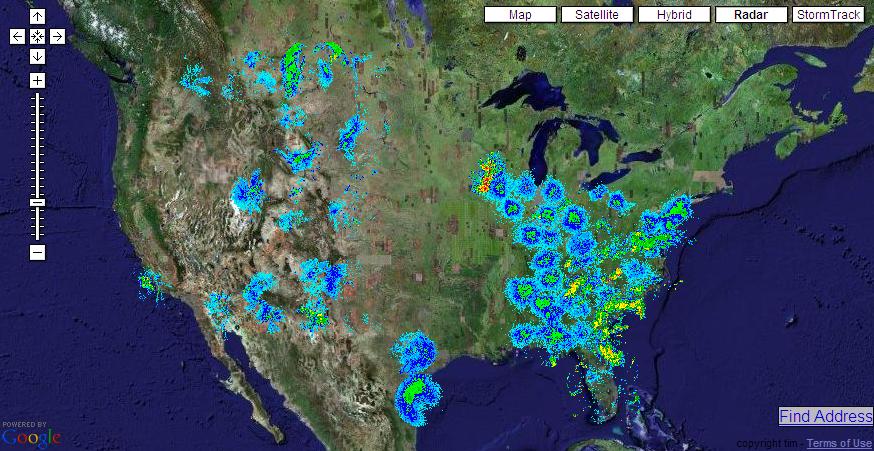
NEXRAD readings can be found here. There is also a Google Mash up with Nexrad results for the U.S. at itsweather.com.
More images of the hang test can be found here. The new CFP for next year can be found here.
Haze over Nuevo Mexico

Sunday, August 27, 2006
It may get cold but we ain't gonna trip

John and I decided to cut the wires for the heaters for two reasons:
- Greg Guzik was not too happy when our amp count was over our self described limit of 0.5 amps.
- We don't know if there is a possibility our amp drawing might trip the fuse set on our payload (1 amp).
Since we did not have any resistance off hand, we decided that, given the fact that the camera would at least produce about 4 watts of heat, it would be able to survive the cold temperatures on the way up and at cruising altitude. I believe we can deal with the uncertainty on the temperature (computed to be OK for an ideal one node case) than the possibility of tripping and shutting down our payload. [ This was written before John left. He and Franky decided to leave the heaters on ]
The payload was cycled through several power on and off of the whole HASP payload and it was shown that our camera started as expected. Our request to the Balloon folks is to power us on as soon as HASP launches. John should have several shots of another balloon sent off yesterday.
Saturday, August 26, 2006
How hot is it going to get ?
Here is a small spreadsheet showing the one node computation that features what happens if we use black or white paint on the outside of the GeoCam box. That box is gonna be white....
John and Franky tested the power-on/off behavior of the camera which acted as it should. They have a concern that the servo pushing the clicker might be pushing too far but the folks at HASP integration told them it would be OK.
There is an expectation to have the flight go for twenty hours. After that, it will be flown by the folks at NASA back to Fort Sumner where it will be shipped back to LSU. We should be either picking up our payload in Louisiana or have it Fedex'ed.
New Item on the checlist: wipe out the card before leaving.
John and Franky should be heading back home today.
Friday, August 25, 2006
Labor Day Launch ?
Here is the latest from Greg Guzik:
Flight Requirements Review went well. We are looking for a desired 20 hour flight at an altitude of 124,000 feet. The maximum lift of the 11 million light is 2,875 pounds and the HASP weight is about 1,850 pounds (including 400 pounds drive up ballast). We may or may not be able to carry more ballast to maintain altitude after sunset. The limit is imposed by the parachute load which is currently set at 2,000 pounds.
We are expecting to complete integration this weekend and do the official hang test next Monday (August 28). At that point we will be Flight Ready and we are projecting a launch window from August 29 through September 8.
There will be a test flight launch and at least a 24 hour standdown prior to HASP launch. Thus, HASP will not launch until after the pathfinder and at least 48 hours after the initial launch. Current best GUESS from the CSBF folks is a HASP launch sometime around Labor Day weekend. Regular weather briefings will begin early next week.
For those of you not in the U.S., Labor day is September 4 this year.
Subscribe to:
Posts (Atom)

